 NuGraf's (USGS) DEM Geometry Import Converter
The NuGraf Rendering System's DEM geometry import converter is a rather complex mechanism that
imports, manipulates and converts
digital elevation model (DEM) data in the USGS format. This form of DEM data is
available from the United States Geological Survey (USGS). Each data set
describes the elevation of semi-square regions of land for various locations
across the U.S.A., Alaska, Hawaii and some surrounding areas of Mexico
and Canada. The most accurate DEM data sets are sampled every 30 metres
(7.5 minute DEMs) while the least accurate are sampled every 3 arc
seconds (for 1:250,000 scale DEMs). See below for a description of the
various DEM dataset types.
Since these datasets are abundant and available freely via the Internet,
this converter can be put to good use for creating realistic (and accurate)
3d landscape geometry for rendering in NuGraf or for export to other 3d
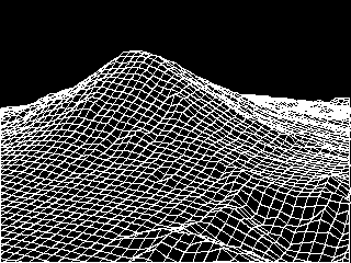
modeling packages such as 3D Studio. As an example, the following is a hidden
line rendering (using NuGraf) of the Mount St. Helens dataset:

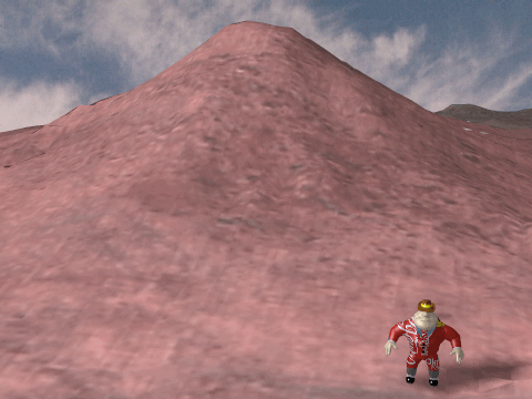
and the following is a simple shaded rendering of the same dataset (being visited
by "Al" the gangster):

Even though this converter was initially
created for an internal project at Okino Computer Graphics, it has nonetheless
become one of the more popular import converters provided along with the NuGraf
Rendering System partly due to its uniqueness and its ability to process very large
DEM datasets. Some typical commerical uses of this converter in industry have been
to create a large and detailed 3d landscape for a virtual reality game (subsequently manipulated in
3D Studio), used for urban planning studies of several towns in California and used
as an interactive tool to visualize USGS DEM data in general.
The following Internet sites provide more information about USGS DEM data:
	http://nsdi.usgs.gov/nsdi/products/dem.html
	http://nsdi.usgs.gov/nsdi/maps/dem1deg.HTML
And the following Internet sites contain vast amounts of USGS DEM data:
	ftp://spectrum.xerox.com/ds9/map/dem
	ftp://edcftp.cr.usgs.gov/pub/data/DEM/250
	http://nsdi.usgs.gov/nsdi/wais/maps/dem1deg.HTML
	http://sun1.cr.usgs.gov/doc/edchome/ndcdb/ndcdb.html
Features of the DEM Converter
DEM datasets typically contain 60000 or more quadrilateral polygons, or
1200000 triangles (for a 258x258 resolution sample; the maximum DEM
dataset size if 2050x2050 which would result in 4.2 million quadrilaterals
or 8.4 million triangles). This is an enormous
number of polygons for most 3d rendering programs so this DEM converter
incorporates two unique options to overcome this problem:
- The converter can skip over samples in the dataset so that only every n-th
sample is used. Rather than importing 258x258 samples, the converter imports
51x51 samples (for a skip factor of 5) which results in only 2601 quadrilateral
polygons.
- Rather than store the entire DEM dataset in single object, the DEM converter
breaks up the data into multiple smaller objects with a common parent. This
has shown to be an effective method to speeding up the wireframe redraws of the
DEM data (by a factor of 2 or 3), and makes interactive user movement of a 3d
camera much faster since each sub-object is only a few hundred polygons.
In addition, certain rendering programs
(such as Okino's NuGraf renderer) use much less memory when many smaller
objects are used rather than one large object with many polygons. By
default each sub-object stores a maximum of 900 polygons; contrast this with
other converters which lump all 120,000 polygons into a single object - few
renderers will be able to render such a large object.
- A default 3d camera is added to the scene which views the DEM data from a
pleasing angle.
- u/v texture coordinates are added to the imported data so that a bitmap image
can be easily draped over the DEM data.
- The converter creates smoothed vertex normals for the DEM data so that
it will appear to be smooth when rendered.
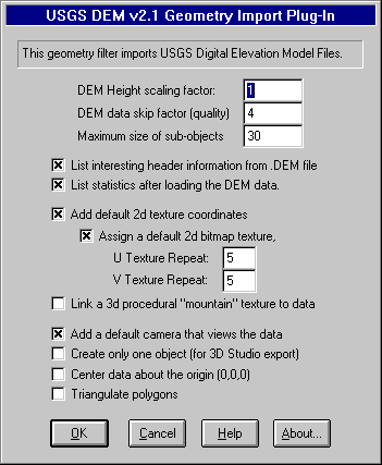
Dialog Box Options

- DEM Height scaling factor
- This option scales the height of the DEM data. It default to 1.0.
Values greater than 1.0 will make the DEM data higher while
values between 0.0 and 1.0 will make the DEM data shorter.
- DEM Data skip factor (mesh quality)
- This option determines the quality of the imported DEM data (it
directly controls how many polygons will be used to approximate
the input DEM data). THIS IS AN IMPORTANT CONTROL PARAMETER!! A
value of 1 results in the highest quality mesh while higher
values (2, 3, 4, etc) result in lower quality, but at the benefit
of reducing the number of polygons in the input data. This number
will cause the converter to 'skip' over every n-th input sample.
For example, if the input dataset size is 258x258 samples, and
the skip factor is set to 4, then the converter will actually
read in the data as if it were of size 65x65 (258/4 = 65). This
will produce 4225 polygons (65x65) instead of 66565 polygons. A
value of 2 or 3 (16641 polygons to 7396 polygons) will produce
good results for a final rendering, while values of 5 to 8 will
produce small datasets ideal for fast previews (2704 polygons to
1024 polygons).
- Maximum size of sub-objects
- By default the DEM data will be cut up into several smaller sub-
objects rather than having all of the DEM data clumped together
into one huge object. This option controls how many polygons will
be put into each sub-object. The default is 30 which will cause
900 polygons (30x30) to be stored in each sub-object.
- List interesting header information from the DEM file
- If the checkbox is enabled (check-marked) then the converter will
print out information about the imported DEM data including the
following information:
- The DEM data description from the file,
- The number of profiles which is the number of lines of sample
data in the X direction,
- The projection mapping type (geographic, UTM or state plane),
- The actual geographic coordinates of the DEM dataset's four corners,
- The minimum and maximum elevations.
- List statistics after loading the DEM data
- If the checkbox is enabled (check-marked) then the converter will
print out the number of objects and polygons created.
- Add default 2d texture coordinates
- If the checkbox is enabled (check-marked) then u/v texture
coordinates will be added to the imported dataset. These texture
coordinates will allow a 2d bitmap image to be easily mapped to
the surface of the data. Please note that the texture coordinates
are aligned with the mathematical bounding quadrilateral of the
dataset, not the actual physical edges of the data (this is
because the physical edges of the data are not square or
precise).
- Add a default camera that views the data
- If the checkbox is enabled (check-marked) then the converter will
add a default camera to the scene which views the DEM data at a
pleasing angle.
- Create only one object (for 3D Studio)
- If the checkbox is enabled (check-marked) then one single object
is created for all of the imported data rather than having the
data broken up into multiple smaller sub-objects (the default).
THIS OPTION SHOULD BE USED FOR DATA DESTINED FOR 3D STUDIO
because 3D Studio requires all polygons to be inside a single
object so that its smoothing algorithm will work properly; if
multiple objects are used then the vertex normals will not be the
same where the sub-objects meet and hence "cracks" may appear at
the junctions.
- Center data about the origin (0,0,0)
- If the checkbox is enabled (check-marked) then the DEM data will
be centered about the origin (0,0,0). Please note that if the
input DEM dataset uses the "Geographic" or "State Plane" grid
types then the DEM data will always be centered about the
origin; this may cause a problem if you want to import two DEM
datasets and have them sit side-by-side; in this case you will
have to physically move the two datasets so that they are
side-by-side.
Overview of the DEM Dataset Types
DEM elevation data spacing varies from 30 meters for 7.5-minute
DEMs to 3 arc seconds for 1:250,000 scale maps. All DEM data
are similar in logical data structure and are ordered from south
to north in profiles that are ordered from west to east.
- 7.5-minute DEM data are produced in 7.5-minute units which
correspond to USGS 7.5-minute topographic quadrangle map series.
7.5-minute DEM data consist of a regular array of elevations
referenced horizontally on the Universal Transverse Mercator
(UTM) coordinate system of the North American Datum of 1927 (NAD
27). These data are stored as profiles with 30-meter spacing
along and between each profile.
- 15-minute DEM data correspond to USGS 15-minute topographic
quadrangle map series in Alaska. The unit sizes in Alaska vary
depending on the latitudinal location of the unit. 15-minute DEM
data consist of a regular array of elevation referenced
horizontally to the geographic (latitude/longitude) coordinate
system of North American Datum 1927 (NAD 27). The spacing between
elevations along profiles is 2 arc seconds of latitude by 3 arc
seconds of longitude.
- 30-minute DEM data cover 30-minute by 30-minute areas which
correspond to the east half or west half of the USGS 30- by 60-
minute topographic quadrangle map series for the conterminous
United States and Hawaii. Each 30-minute unit is produced and
distributed as four 15- by 15-minute cells. 30-minute DEM data
have the same characteristics as the 15-minute DEM data except
that the spacing of elevations along and between each profile is
2 arc seconds.
- 1-degree DEM data are produced by the Defense Mapping Agency
in 1-degree by 1-degree units which correspond to the east half
or west half of USGS 1- by 2- degree topographic quadrangle maps
series, for all the United States and its territories. 1-degree
DEM data consist of a regular array of elevations referenced
horizontally using the geographic (latitude/longitude) coordinate
system of the World Geodetic System 1972 Datum. A few units are
also available using the World Geodetic System 1984 Datum.
Spacing of the elevations along and between each profile is 3
arc seconds with 1,201 elevations per profile. The only
exception is DEM data in Alaska, where the spacing and number of
elevations per profile varies depending on the latitudinal
location of the DEM.
 NuGraf's (USGS) DEM Geometry Import Converter
 NuGraf's (USGS) DEM Geometry Import Converter


 Return to the NuGraf Rendering System main page.